On September 4, local time, the United Nations General Assembly passed the "Correct the Map" resolution with 164 votes in favor, 1 against, and 6 abstentions. The resolution encourages governments, educational institutions, international organizations, media, and tech platforms to adopt equal-area projection methods like Equal Earth when presenting the relative sizes of different regions.
Jointly launched in 2025 by African advocacy groups Speak Up Africa and Africa No Filter, the "Correct the Map" campaign aims to reduce global reliance on the 457-year-old Mercator projection and promote equal-area projections that preserve true geographic proportions. The initiative gradually entered the African political agenda before reaching the UN General Assembly.
Fara Ndiaye, Co-Founder and Deputy Executive Director of Speak Up Africa, is a core leader behind the movement. On September 7, Ndiaye spoke with National Business Daily (NBD) about how cartographic bias reinforces systemic economic undervaluation—and why digital platforms, schools, and publishers must adopt a new world view.
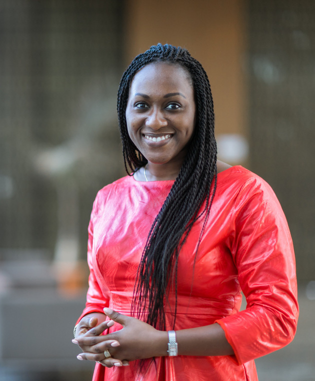
Fara Ndiaye Photo/Provided to NBD
"It is not a technical problem—it is a question of who benefits from the habit"
NBD: What first convinced you that the Mercator projection was not simply a technical cartographic issue, but a problem serious enough to require an international campaign?
Fara Ndiaye: The moment that convinced me was not a map. It was a child. I have spent my career in advocacy on health and education across Africa, and one of the things you learn is that the most powerful policies are the ones nobody notices, because they have become the furniture of everyday life. The Mercator projection is exactly that. It hangs in every classroom, opens on every phone, and sits behind every television weather map. Nobody decided that it should be the picture of the world. It simply never went away.
When you then ask a ten-year-old in Dakar, or in Beijing, or in Paris, to point to the biggest continents, they will reliably underestimate Africa. On the Mercator map, Africa and Greenland look roughly the same size. In reality, Africa is about fourteen times larger. Africa can contain the United States, China, India, Japan and most of Western Europe combined. Very few people, anywhere in the world, have ever seen it drawn that way. That is a knowledge failure on a planetary scale, repeated every school day for centuries, and it happens to work systematically against one continent.
The second thing that convinced me was that the fix already existed. Cartographers have known about the distortion since the projection was created in 1569, and equal-area alternatives have been available for decades. The Equal Earth projection, published in 2018, preserves the true relative size of continents while keeping familiar shapes, and it is free to use. So the problem was never technical. It was a question of habit and of who benefits from the habit. When a distortion is that old, that widespread, that easy to correct and that consistently unfavourable to Africa, it stops being a curiosity about cartography and becomes a question of representation. That is when Speak Up Africa and Africa No Filter decided it needed a campaign.
"Old maps served European navigation, shaping the mental models of today's decision-makers"
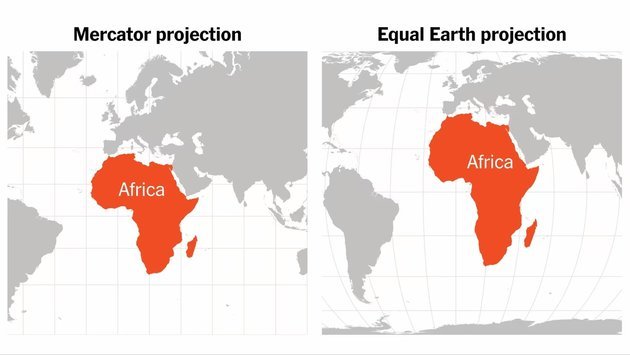
NBD: The Correct the Map initiative argues that shrinking Africa visually can influence how people perceive the continent. How does map representation affect public and economic perceptions?
Fara Ndiaye: People systematically misjudge the size of countries and continents, and the direction of the error follows the Mercator distortion. Studies asking people to estimate or rank land areas find that Africa, South America and South Asia are consistently underestimated, while Greenland, Russia, Canada and Northern Europe are overestimated. This is not controversial among geographers.
Second, visual prominence on a map, whether through size, centrality or position at the top, is read as significance. Mercator, drawn in Europe for European navigation, enlarges the North Atlantic world and shrinks the equator. The people who have used it for five centuries have absorbed that hierarchy without ever being told it was there.
Third, investment decisions are made by people, and people carry mental maps built in childhood. When a continent of 1.4 billion people and 54 countries is habitually pictured as a mid-sized country, it is easier to treat it as one market, one risk category, one line in a portfolio. The distortion does not cause the underestimation on its own. It reinforces it, quietly and continuously, alongside media coverage and history curricula that do the same work.
Consider what is routinely underestimated. Africa has around 1.4 billion people today and will have close to 2.5 billion by 2050, when one person in four on earth will be African. It has the youngest population of any continent, with a median age under twenty. It holds a large share of the world's reserves of cobalt, manganese, platinum-group metals and other minerals central to the energy transition, and around 60 percent of the world's uncultivated arable land. The African Continental Free Trade Area, with 54 signatories, is the largest free trade area in the world by number of member countries. Yet in most boardrooms outside the continent, Africa is still discussed as a single place, usually in the language of risk and need rather than scale and opportunity.
Part of the answer is that for the entire lifetime of everyone making decisions today, the picture of the world on the wall said so. The map did not create the underestimation. It gave it a shape, and it made it feel natural.
NBD: Some critics may argue that changing a map is largely symbolic. How would you respond?
Fara Ndiaye: I would agree that it is symbolic, and then ask the critic which symbols they think do not matter. Flags are symbolic. Currencies are symbolic. The name of a company is symbolic. Nobody in business treats those as trivial, because everyone understands that perception is a precondition for the material decisions that follow.
NBD: Africa's economic importance is rising globally. Can a more accurate visual representation change how international investors view the continent?
Fara Ndiaye: Indirectly, yes, and I think Chinese readers may understand this better than most. China has spent decades correcting how the world pictures China, and it knows that perception and economic weight do not adjust at the same speed. The reality changed first; the picture in other people's heads lagged for years and had to be actively updated.
An accurate map will not change a credit rating. What it does is change the default picture in the heads of the people who decide where to look. When you see Africa at its true scale, with the United States, China and India fitting inside it with room to spare, you start asking different questions: not 'whether Africa' but 'which Africa', which country, which sector, which city. That shift in the question is where the economic value lies.
"Let the next generation learn from an accurate picture, and push digital platforms to change default settings"
NBD: The UN resolution is non-binding. What would constitute real success for the campaign over the coming years?
Fara Ndiaye: The resolution is not binding indeed. No atlas changed on 4 September. What changed is that 164 governments gave every ministry of education, every publisher and every technology company a reference point they did not have before. The burden of proof has moved to those who want to keep the distortion. Success over the next few years means turning that reference point into practice, and we measure it in four places.
First, the United Nations system itself. If UN agencies, reports and public materials move to equal-area projections, member states and international organisations have a model to follow.
Second, education. Success is ministries of education, beginning with African Union member states, integrating equal-area maps into curricula, textbooks and classroom materials, so that the next generation learns from an accurate picture.
Third, media and publishing. Success is newsrooms and publishers adopting editorial standards that use accurate projections wherever the relative size of regions matters.
Fourth, and in many ways the most important, digital platforms. Most people now meet the world through a screen, and the default settings of a handful of technology companies shape perception more than any printed atlas ever did. Success is those defaults changing wherever the true scale of continents matters."
NBD: Are you now directly approaching tech companies, publishers, and educational authorities to adopt Equal Earth?
Fara Ndiaye: Yes. That is the entire next phase of the campaign. The advocacy phase was about establishing the principle. The implementation phase is about commitments, and we will be approaching each of those groups directly.
I would add that this is an invitation, not a confrontation. We are not asking anyone to abandon Mercator for navigation, where it remains the right tool. We are asking that a projection built for sixteenth-century sailors stop being the default picture of the twenty-first-century world. Any company or institution that wants to be on the right side of that change will find us ready to work with them. A fair map benefits everyone, because it teaches all of us to see the world, and Africa, as it really is.
Editor’s note: The interview has been reordered and lightly edited for clarity and written presentation, without altering the substance of the responses.


 川公网安备 51019002001991号